Cycling in Mexico: Toluca to Valle de Bravo by Mountain Bike
Valle de Bravo is a pretty resort town in central Mexico, two or three hours driving from Mexico City. I live in Toluca, which is roughly halfway between them, a two-hour bus ride from Valle de Bravo.
As the name indicates, it’s a valley, one that’s been flooded into a huge reservoir that provides water for both Toluca and Mexico City. The reservoir is the area’s prime attraction, besides the tranquil town of winding cobblestone streets, colorful brick buildings with red-tile roofs, and small restaurants serving locally caught trout and a wide variety of Mexican food. There’s even a high lookout from a rocky promontory between the town and the water.
If you want to visit Valle de Bravo but don’t want to deal with public transportation (or ride your bike there, like me), check out this Private Tour to Valle de Bravo from Mexico City.
People come to Valle de Bravo to enjoy the area’s perpetually pleasant weather, take a cruise in one of the boats that leaves from a busy wharf, or do more extreme activities like paragliding from one of the peaks surrounding the lake.
Besides cycling, paragliding is one of the most popular activities in Valle de Bravo. Check out this reliable and highly-rated tour for paragliding in Valle de Bravo.
As it’s close to Toluca, I’ve been there many times, always to visit the town or attend a wedding party at one of the fancy lakeside haciendas nearby. But for years, I’ve had another kind of trip in mind—riding my bike all the way there from Toluca on a series of trails and dirt roads that crisscross the pine-forested mountains all the way down to Valle de Bravo.
Although I knew where to find the trails, the ride isn’t something to attempt all alone or with friends who don’t know the route. I needed to wait until one of my mountain biking friends who’d already done it was ready to go. So, for years now, I would mention it during other rides—have you done the ride to Valle de Bravo? Are you planning to do it again? Please, make sure to invite me the next time. I really want to go.
This persistence paid off last Sunday. My friend Marco invited me by text a few days earlier, and I accepted immediately.
It was a perfect day—cold, even for December, but clear, with barely a cloud in the sky all day. It’s been raining hard lately, with some nasty overcast days and lots of wind, but that all cleared up on Saturday. Sure, it was chilly in the shade of the deep forest, but that meant that many of the hopelessly muddy sections were frozen into crunching fissures that were a little slippery but still gave enough traction for climbing.
I left my house at 6:30 for the half-hour ride to the meeting point at a gas station on the highway to Valle de Bravo. It was downright freezing outside, but I was well-prepared with long pants (I attached the legs of my convertible hiking pants), wind-proof cycling gloves, and a buff pulled over my ears.
Marco came right on time at seven, just a few minutes after I arrived, and then Toño, someone I recognized from other rides but didn’t know very well. It would be only the three of us today. Both had already done the ride, but Toño was the guide, since he remembered the route and had the proper apps and maps on his phone to check during the ride.
We spent the first hour riding on the highway leaving the city. I call it a highway, but it’s basically a long mostly two-lane road going due west where people drive really fast. We stopped at the crossroads for the Nevado de Toluca Volcano, at a spot called Las Kekas, named after the several quesadilla shops at the base of the mountain. Take a left here, and the road takes you way up to the extinct volcano, another great spot for mountain biking where I go regularly. Keep going straight, and the road twists and turns down to Valle de Bravo.
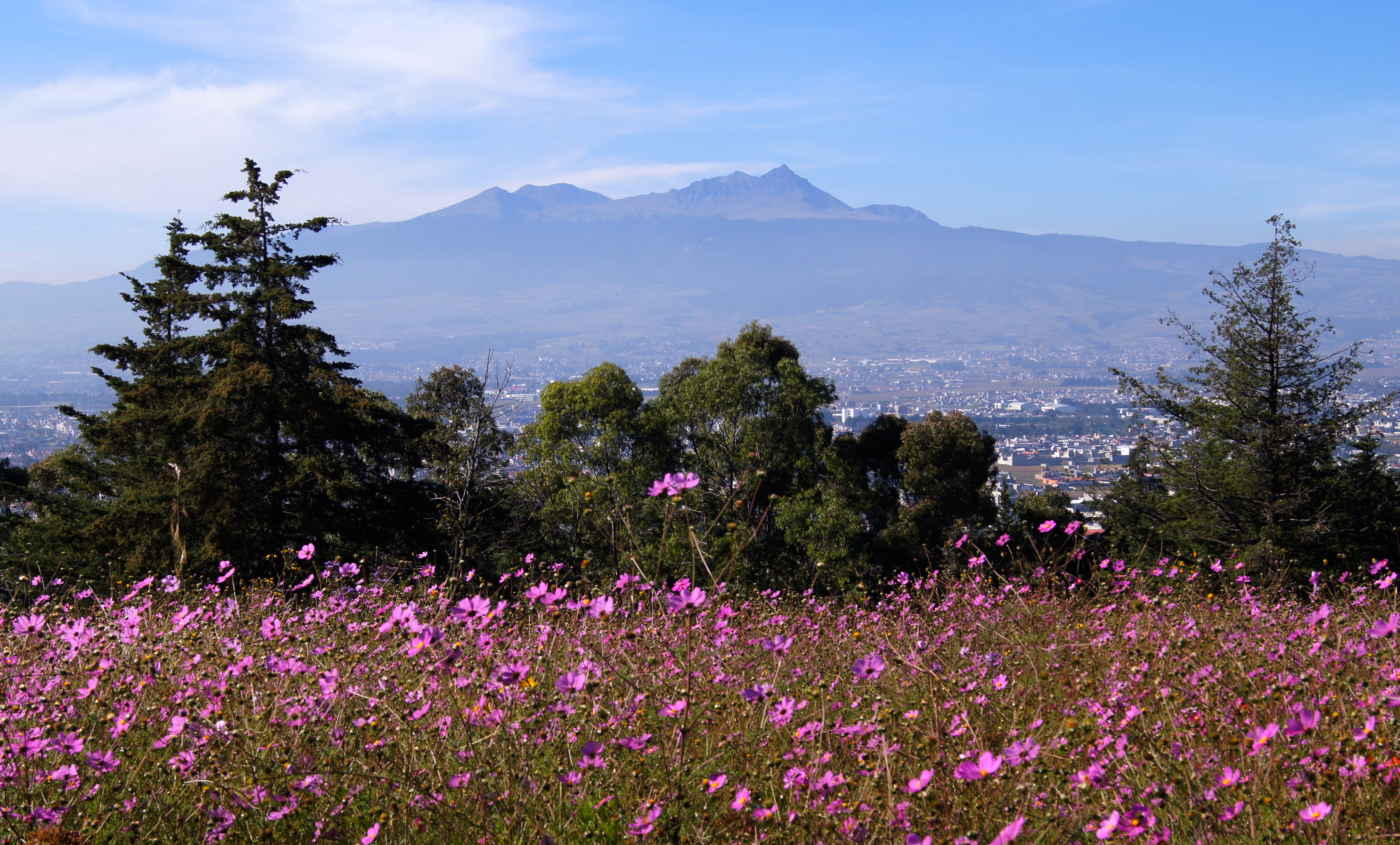
Before Las Kekas, the highway passed large open fields that gave expansive views of the broad snow-capped crater walls of the volcano, several dusty towns of unpainted concrete homes and narrow pothole-filled roads, and some dismal gravel pits. But after the long climb to Las Kekas, it’s all tall pine trees above a sandy forest floor covered in moss and pine needles.
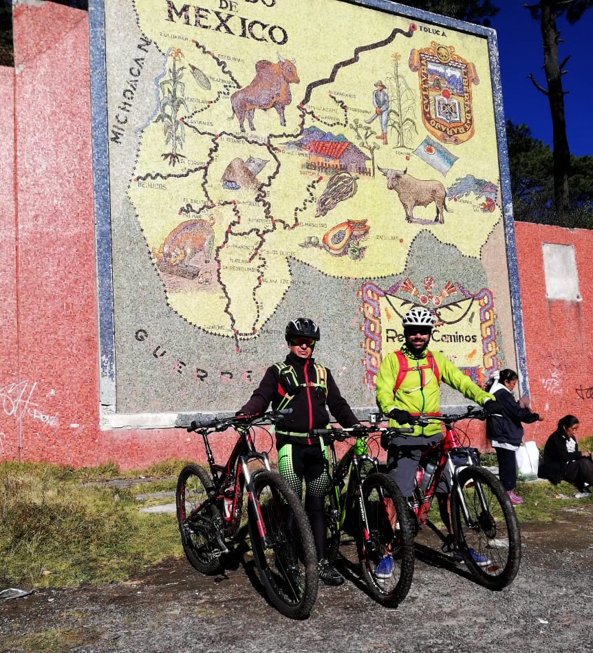
We left the road at Las Kekas, where we chatted with the many cyclists gathered there to do a ride on the lower slopes of the volcano. Our first destination was La Mapa, a huge tile map of the State of Mexico (the state containing Toluca and Valle de Bravo) on the side of the road, which marked the beginning of the route to Valle. We could have gotten to La Mapa on the road, but instead we took dirt roads through the tiny communities between Las Kekas and La Mapa. We came to mountain bike, after all.
There were lots of people outside for an early Sunday morning, and even more dogs. Most just watched as we passed, but sometimes they barked and chased us—funny collections of all kinds of breeds, from big German shepherds to little chihuahuas, and all sizes in between, especially the mid-sized, average-faced mutt that usually comes in dirty yellow or black. The mutts are usually the least interested in chasing cyclists, while the little dogs are always the most eager. In fact, both times I’ve been bitten by stray dogs in Mexico, it was a little nasty one.
These cinderblock communities surrounding the Nevado de Toluca Volcano are some of the coldest in Mexico. The people gathered outside wore woolen gloves and winter hats, were wrapped in checkered blankets, and drank styrofoam cups of atole, a thick corn drink that goes with tamales. Everyone waved and said good morning. The little children pointed and laughed.
The two-track farm roads crossing these communities were of fully frozen mud. Between farms, there were gentle uphills to forested sections where sometimes the road broke out of the trees into welcome sunlight. On the last of these ridges, I checked my phone—a little after nine. Then a sharp descent and we arrived at the clearing in front of La Mapa.
Thank you to Marco for most of these pictures
The trail—another overgrown two-track—began between La Mapa and the road to Valle. We’d descended far enough into warmer elevations that most of the mud was no longer frozen, but thankfully hard-packed enough to ride over without getting stuck. There were lots of wide muddy puddles that sometimes we could ride on the edge of, but usually had to go right through. They were never too deep and were solid enough that I only got briefly stuck once, dunking my foot into the chilly black water. The trees were high and thick, so the air was still cold, but with the higher sun and lower elevation I took the legs off my convertible pants and stuffed my neon yellow windbreaker into my backpack after a particularly long climb.
I was the first to reach a fork in the dirt road in an open grassy area. Going left would keep us closer to the main road, and to the right was a high ridge of rocky mountains. I assumed we’d go left, despite a silver arrow on a tree pointing to the right. Sure enough, Toño guided us right, farther from the road and deeper into the wilderness. We stayed on the slope of the mountain ridge for a long time, twisting along the slowly narrowing path filled with more and more puddles. All the while, higher and rockier mountains loomed ahead.
On a long downhill, my tires simultaneously hit a section of smooth, hard-packed pitch-black dirt covered with patches of flattened moss, and the bike slipped right out from under me. I went down fast and hard, hitting my hip, shoulder, and head on the ground. There was no damage, however, other than a few big red welts. It’s moments like these when I’m glad to be wearing a helmet, and also that I’ve had enough experience crashing that I know how to do it right—never stick out a hand to break the fall, but tuck in and take it. Not that I had much time to think, as it happened so fast. I shook out the stars in my vision, told Marco I was alright (he was in front and stopped when he heard me hit the ground), and got back on, reminding myself never to brake on mossy sections.
Soon afterwards, we took a long curve and the dirt road was no more, reduced to a narrow singletrack almost hidden by the overgrown vegetation all around. Leaves and branches snapped against my face and snagged my arms and legs.
Then we got into the tree trunks. Toño had warned us about all the trees that had fallen over the trail. We crossed at least 20 of them. We’d lift our bikes over the low ones and then scramble over them. For the ones suspended over the trail, we could either push our bike and then crawl under them, or if there wasn’t enough space, flip the bike over top and then get over by straddling the trunk. Either way, they slowed our progress considerably.
We took a little break here in a patch of sunlight on this section of trail. Marco and Toño talked about the new Freddy Mercury movie, asking if I’d seen it. No, I hadn’t. Great movie, they said, even if you’re not really a fan of Queen. I don’t really like going to see movies, I said. Too many people making noise and looking at their phones. Marco said that he saw it in the IMAX in downtown Toluca. It was early afternoon on a Friday, and there were only five or six other people in the theatre. Toño said that he liked Queen, but there were other English-singing bands he liked more, like the Cowboy Junkies and Lou Reed. He said that he had four versions of “Sweet Jane”—one, the original by Lou Reed (he meant the Velvet Underground), a live version by Reed, the cover by the Cowboy Junkies, and I can’t remember which was the fourth.
We set off riding again. The big rocky ridge was still in front of us when we began a long climb that took us through a gap we couldn’t see earlier. The trees were smaller and scragglier here, and lots of sunlight made it through to the muddy trail. Here we saw the first butterflies. Every spring, millions of monarch butterflies from all over North America migrate to this part of Mexico. From February to March, they cover every leaf, branch, and trunk, and when they take off in unison, they blot out the sun, filling the sky like black smoke.
December is a little early for the monarch migration, but once we were on the other side of the rocky ridge, there were a few fluttering above the trail. Now we were descending and picking up speed. The trees were thin enough that we were finally riding under the full sun. I was in the front of the group again and took a long curve into a big straight descent. As I rode faster and faster, more and more butterflies took off from their perches on the sandy banks of the trail. For a while it was like they were flying with me, fluttering all around me as I rode downhill, encouraging me to float over the rocky and puddly trail like how they floated through the clear mountain air all around.
After another curve, the trail was no longer a simple trail, but also a stream. Cool mountain water flowed over rocks and pebbles. There was no mud and no getting stuck, but a lot of splashing and getting wet. The sun reflected off this water as I took the turns hard, standing up on my bike, absorbing the shocks with bent knees and elbows.
The trail entered dense pine forest again and the stream branched off from it, becoming a simple stream again. Here was another crossroads where I waited for my friends. Toño consulted his app and we took the correct direction on another truck-sized dirt road. It led out of the forest and crossed a wide grassy field that gave panoramic views of the steep ridge we’d been riding along.
From here we began to descend rapidly on curving dirt roads through more temperate forests. The pine trees were shorter with wider canopies, and the ground was sandier with much less moss. Many sections of the road were extremely rough, marked by deep runoff gullies and covered with softball-sized stones. We still went fast, but with a lot of bouncing and braking. In fact, as I write this, my palms are still sore with faint purple bruises on the meaty pad opposite the thumb.
There were many crossroads on these roads, at which we’d stop so Toño could check the route. Soon we entered another grassy valley. To our left was a large rocky peak with tall cliffs like long canine teeth. As we rode down the road crossing the bowl-like valley, the volcano came into view from behind the peak. Instead of the broad, broken ridge of crater peaks that you can see from the city of Toluca, from here it was a solid snowy wall with two high points on either side.
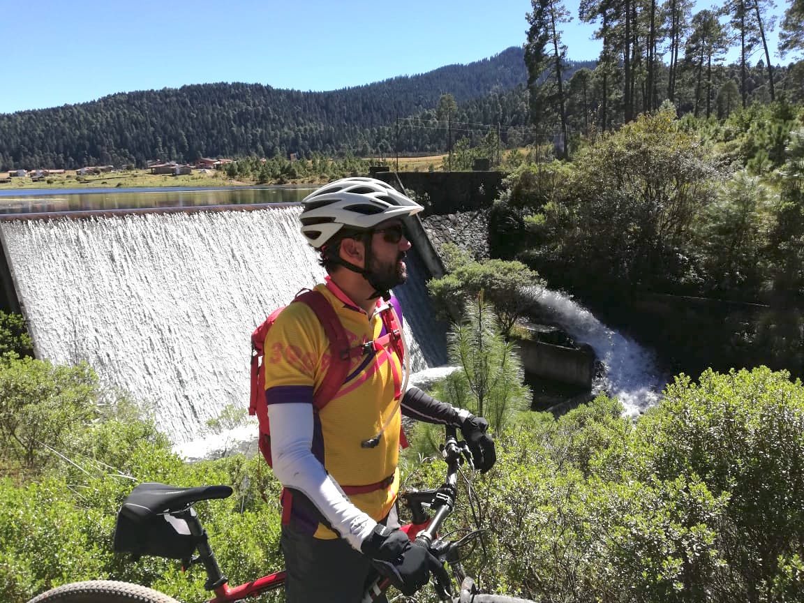
The path reached a glistening lake with wooden cabins on the opposite shore. On our side, a family sat at a picnic table next to the water. Signs told us we were in Corral de Piedra park. The dirt road followed the shore, offering even better views of the volcano, and then passed an artificial waterfall sliding down the dam at the far end of the lake. Marco and I stopped there for a few minutes to take pictures and watch the patterns of water pouring down the slope.
We then caught up to Toño. We passed a large trout farm of many ponds and pools. After more crossroads that Toño knew from memory, we rode into an open area and a small community next to another lake, where we stopped at a little store. Dirty-faced children came up asking us to buy them something. I sat outside on a wooden bench answering a boy’s questions about my bike while Toño and Marco shared a beer inside the store. I like beer, but not in the middle of a bike ride. My Mexican cycling companions, however, often drink beer while on a break, claiming it’s good for hydration. For me, it makes me sluggish and my stomach heavy—much better for after the ride with an enormous meal.
When Marco came out, the boy approached him, again asking for money. Marco handed him some change and spoke to him for a while, leaning down with his hand on the boy’s shoulder, saying something about how he should be in school. I’ve known Marco for years, but I learned something new about him that day. I witnessed his generosity several times later on while we were eating in Valle de Bravo. He gave change to anyone who asked, bought a lollipop in the shape of a flower from a woman selling them, and even gave money to the guy who stood outside the restaurant rapping nonsense for two minutes.
We remounted again and cruised through the small, sunny community. By small, I mean that this place comprised fewer than ten buildings, including the store and a tiny pastel-painted church. The rest were rectangular wood and adobe homes. Big herds of sheep wandered between them. Horses stood in the open, munching grass. And there were more than a few couples or families laying out in the fields under the sun. It was afternoon by now, and although the air was still chilly in the woods, out in the open the sun was bright and warm.
We didn’t see another community for the next hour or so of riding on a maze of dirt roads, the route through which Toño somehow navigated by memory, until another long descent through pine forest until a more modern looking community of the stylish earth-tone painted adobe and tile-roofed homes that are common in Valle de Bravo. As usual, there were lots of dogs about and we got chased a few times. Everyone outside waved at us while hanging laundry, feeding dogs, or leaning over the engine of a beat-up car. The road became concrete through steep sections, and big agaves grew on its high crumbling banks.
Wilderness sections between these communities became smaller and smaller until we were finally riding through a proper town, with churches, farms, ranches, and convenience stores. To our left we saw high netting suspended on tall poles. What’s that, asked Marco. That’s a golf course, I said. And I knew where we were, in the little town next to the Avandaro Country Club, where I’d gone to a wedding the previous spring.
Toño asked directions a few times, trying to find the trails and dirt roads to take us all the way down to Valle, but the answer was always the same—the road’s right over there. Sure enough, we left the town on a road right next to the entrance to the golf club and pulled onto the main road to Valle.
This was a fun, fast downhill for about 30 minutes. There was no shoulder on the narrow road, but we were going fast enough that, for the most part, no cars tried to pass us. And even if a car crowded us from behind, soon enough there would be a speedbump in the road, which slowed down the cars but not us. We flew right over them.
Many turns later, the road became cobblestone, the buildings became taller, and we could see the blue of the lake in front of us. One more big curve and dip, and we entered the town of Valle de Bravo.
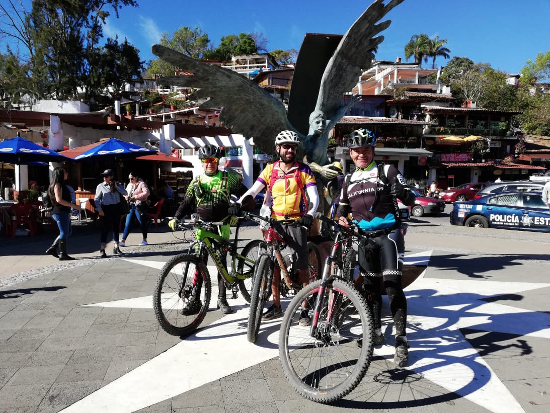
This was the area right by the wharf for the boat trips. It was full of people, mostly weekend tourists from Mexico City. We walked our bikes onto the area in front of the boats and asked someone to take our picture next to the winged statue there.
It was time to eat. We’d agreed on trout earlier, inspired by the trout farms, and there was a small seafood restaurant across the road from the wharf. There were only four tables in the open-air restaurant, and they were all full, so we decided to wait in the ice-cream shop next door. Both of my friends bought an ice cream, and Marco bought a michelada, a liter of beer mixed with tomato juice, lime, and dry chili pepper in a big paper cup. The owner of the ice cream shop was friendly and let us stash our bikes inside, and even agreed to let us eat our trout inside the shop, where there was plenty of space.
The waiter from the seafood restaurant brought us menus and we all ordered the same thing—trucha empapelada, which is the whole trout steamed with vegetables inside tinfoil (called tin paper in Spanish, hence the name empapelada—papered).
Before the food was ready, a table had opened up in the restaurant, so we moved over there. The trout was small but delicious. It didn’t need any sauce—the fish’s flesh and the onion, tomato, and orange-colored chile manzano inside was enough for flavoring. We ate slowly and Marco ordered a shrimp cocktail at the end.
We’d rolled into Valle at about 3:30, and after our meal and a few beers, it was already five o’clock, time to go to the bus station to catch the bus back to Toluca. Where is it? Well, up that hill and your second right.
The hill turned out to be a steep and bumpy cobblestone road, not so easy on a full stomach after riding all day. At the top of the hill was a long curve, which eventually gave a view of the steep rocky point that overlooks both the town and the lake. On my first trip to this part of Mexico more than ten years ago, I’d come to Valle de Bravo and climbed that point with my then-girlfriend, now-wife, whom I was visiting then. We took pictures up there next to an iron cross covered with flowers. Back then the wharf area, where I’d just eaten the trout with my friends, was nothing more than a grassy field with water lapping at the low shore. A single wooden pier of cracked and splitting planks reached out into the lake.
Where’s the bus station, Marco asked a passerby. Next right, and then up the hill. Yes, one more hill. It was slow going, but we did it. Once the road leveled out, a bus came into view, with “Toluca” written over the windshield. It stopped to let someone on, and we waved at the driver. He got out of the bus to talk to us—sure, you can get on. Put your bikes below. As I slid my bike into the luggage compartment, I saw a huge line of honking cars behind the bus. Oh well. We got on, and were on our way.
We found seats in the back. Both of my friends fell asleep before the sun went down. I peered through the darkness at the tall trees and occasional open fields between them. I spotted the entrance to the Avandaro Country Club. From there the bus took another hour and a half to get to the point on the highway near gas station where I’d met Marco and Toño in the morning, where the road to my apartment started. I got off the bus, fixed the lights onto my bike yet again, and rode home in the cold darkness. It was 7:30 when I turned the key to my apartment, exactly 13 hours since I’d left that morning.
This page contains affiliate links, which means I earn a small commission if you purchase something after clicking a link on this site. I receive this commission at no additional cost to you.
Posted on December 8, 2018, in cycling / MTB, Mexico and tagged bicycling mexico, cycling in Mexico, mountain biking, mountain biking mexico, toluca, toluca bikers, valle de bravo. Bookmark the permalink. 4 Comments.


Prefer to read more about the town itself and the different areas by the lake.
LikeLike
Best story yet! I loved the part about being bitten by nasty little dogs but my favorite part was your wonderful description of the butterflies.
LikeLike
Pingback: The Monarch Butterfly Migration to Mexico | No Hay Bronca
Pingback: Travels in Mexico, 2019: Part 1 | No Hay Bronca